April 26, 2017 | Water in the West | Insights
Prior to the passage of the landmark Sustainable Groundwater Management Act (SGMA) in 2014, groundwater withdrawals in California were largely unregulated. As part of initial compliance with this Act’s requirements, groundwater basins designated by the California Department of Water Resources (DWR) as high or medium priority must form new agencies—Groundwater Sustainability Agencies (GSAs)—by June 30 of this year. These agencies will be responsible for developing and implementing plans to ensure that each basin is managed sustainably within 20 years of plan adoption.
DWR estimates that the 127 high and medium priority basins account for 96 percent of groundwater pumping in the state. However, basins like the San Mateo Plain Subbasin (Basin) that are not currently used as a primary water supply source (and thus have been categorized as low and very low priority and not subject to SGMA regulations), are increasingly being looked at to serve as a supplemental water supply. This blog post follows the public process that the County of San Mateo initiated last year to better understand the Basin.
San Mateo Plain Subbasin
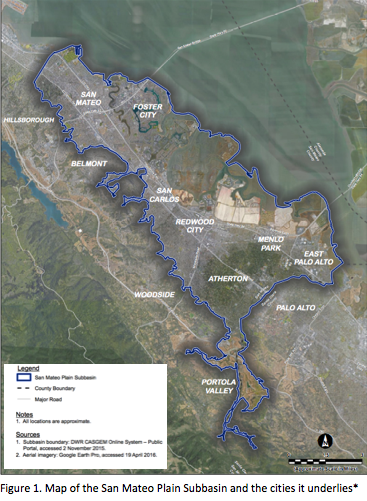
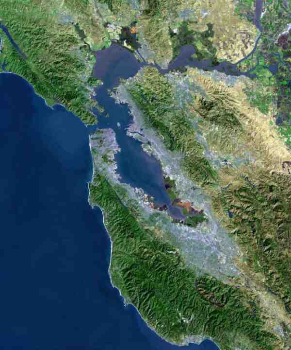
Despite the fact that the Basin underlies major population centers—spanning from the City of San Mateo in the north to Menlo Park in the south—it is a relatively small basin with limited withdrawals (Figure 1). Limited groundwater pumping in the Basin means that groundwater levels have remained relatively stable over the past 40 years and led DWR to designate the Basin as a “very low” priority basin (Figure 2). However, limited reliance on the resources has not always been the case. Groundwater was the primary drinking water source for the county before the completion of the Hetch Hetchy water supply system in the 1960’s.
Currently Hetch Hetchy accounts for nearly all of the drinking water supplies in the Basin, with the exception of two mutual water companies in East Palo Alto and Menlo Park. Many irrigation wells remain active and contribute to some ongoing groundwater pumping in the Basin. Because of its size, the Basin has been shown to respond relatively quickly to changes in groundwater pumping, as evidenced by some negative effects from overuse and lack of management prior to the 1960’s such as seawater intrusion and subsidence.
An increase in the amount of groundwater pumping in the Basin could ultimately result in it being designated as a medium or high priority basin (DWR will conduct a basin reprioritization later this year) and thus subject to SGMA requirements. Considering these prospects, San Mateo County conducted a study to better understand the Basin and increase public knowledge about its groundwater resources. The project is funded by Measure A, which is a half-cent sales tax passed by voters in 2013.
Public engagement and transparency are two components being emphasized by the County as it proceeds with the study. The County is actively encouraging stakeholder and public participation in the project by conducting individual meetings with stakeholders and holding public presentations every few months to give updates and solicit feedback as the project progresses. To get involved in these meetings, check the project website for schedules and locations.
Additionally, the County has developed an online, publicly accessible database where all information being collected about the Basin is housed. All presentations and reports associated with the project can also be accessed online. By beginning the process with open and transparent protocols for data, the County is setting a strong precedent for the sharing and accessibility of data in the future.
The study, which serves as a strong example of voluntary management and precautionary planning, began in April 2016 and is divided into three phases.
Phase One
Completed in January 2017, phase one focused on increasing public awareness, gathering and compiling existing data, assessing potential risks to the Basin, starting to develop an initial conceptual and numerical model of the Basin, and evaluating potential management strategies. A preliminary report indicates:
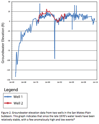
- Basin Conditions: At present, the Basin is full; however, historical data indicate that the Basin responds rapidly to pumping increases. For example, despite relatively stable conditions in the Basin there is an abrupt decrease in the groundwater level around 1990 (Figure 2). As a result, development of the resource in the future should be undertaken with caution to ensure sustainable levels of groundwater pumping.
- Water Quality: Many wells in the Basin, particularly shallow wells that are prone to contamination, have concentrations of total dissolved solids, iron, and manganese above secondary maximum contaminant levels (MCL’s). It should be noted that these are secondary drinking water standards, guidelines recommended by the Environmental Protection Agency, but that these are non-enforceable. These elevated concentrations have generally been stable overtime, indicating that water quality is not degrading. However, individual wells in the Basin should be tested for irrigation purposes and may require treatment for municipal purposes.
- Quality of Data: Wells across the Basin provide a picture of groundwater conditions, although many of these wells are clustered in the southern and far north areas of the county. Additionally, because many of these wells were drilled after 1990 they do not provide an extended record of how the Basin has responded to changing conditions through time. During phase two of the project there will be an effort to collect additional data through new partnerships in order to increase the period of record available over time.
- Management Strategies: When evaluating the potential project opportunities and management strategies, stakeholders indicated a high interest in increasing the technical understanding of the Basin. There was particular interest in improving the collection of data and enhancing basin-wide and regional partnerships, including any opportunities to coordinate on cost sharing. The County is currently reaching out to agencies throughout the area to ensure coordination of efforts at the regional scale. For example, the Bay Area Water Supply and Conservation Agency (BAWSCA) is currently facilitating a Groundwater Reliability Partnership (GRP) for the Basin. This group focuses on engaging stakeholders to work together and share information on various water projects in the Basin and surrounding area. The County has partnered with BAWSCA to provide updates and solicit feedback on its project.
Phase Two
Phase two of the project began in February 2017. This phase focuses on filling the data gaps identified in phase one. This will be done by fostering the relationships and partnerships developed in phase one and developing new partnerships within the county and the region. During this phase, the groundwater database as well as the conceptual and numerical model will be updated using the new data collected. Phase two is scheduled to be completed in December of this year.
Phase Three
Set to run from September 2017 through to April 2018, phase three will focus on using the numerical (or computer) models developed in phase one and two to run scenarios to better understand how changing conditions might affect the Basin. For example, what impact would an increase in groundwater pumping or sea level rise have on the basin? At the conclusion of phase three a final report will be released summarizing the findings of all three phases of the project.
Conclusion
Groundwater is a potentially valuable resource for the county of San Mateo and the communities within it. However, as evidenced by past issues with groundwater contamination and subsidence, this resource must be developed responsibly. Doing so requires a clear understanding of the resource and the array of management options. Undertaking the process of data acquisition and public consultation before legal requirements to do so and in advance of significant resource depletion, enables local communities to set themselves up for long-term success.
**Figures 1 and 2 are modified from the San Mateo Plain Groundwater Basin Assessment Preliminary Report, Figure 1-1 and 6-29 respectively.