December 04, 2020 | Stanford Woods Institute | News
Groundwater managers across the Central Valley striving to attain sustainability for underground aquifers are largely operating without a map. California’s 2014 Sustainable Groundwater Management Act (SGMA) requires managers to attain groundwater sustainability by 2040 or 2042 depending on the basin. However, critical knowledge is lacking on where water flows from the Sierra Nevada Mountains to recharge water supplies underground, and where there are sites that could be used to enhance the recharge, making it difficult to ensure water depleted through pumping and irrigation is balanced by new water coming in.
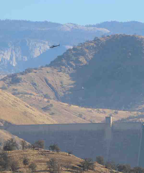
Taking Flight
“With the commitment to meeting the goals of SGMA came the recognition of all the data gaps. How can we get the information we need about California’s groundwater systems?” said Rosemary Knight, a professor of geophysics in the Stanford School of Earth, Energy & Environmental Sciences. “You can’t get sufficient coverage by drilling wells so, in this case, we’re flying the foothills – using a helicopter to carry a geophysical system to image beneath the ground.”
Knight is leading a team of researchers conducting an airborne electromagnetic (AEM) survey of the Sierra foothills and edge of the Central Valley in order to image the rocks and sediments that control how water moves underground. The selection of the AEM system (SkyTEM) and the acquisition and processing of the AEM data is being handled by Aqua Geo Frameworks. The flights, which are taking place this week, will acquire information essential to advancing groundwater science. Equally important, by collaborating with groundwater managers in Tulare and Fresno Counties, the research team is also helping to inform and impact managers’ sustainability efforts.
Groundwater depletion is a serious issue in the Central Valley, a region that produces one fourth of the nation’s food and is responsible for 20% of all groundwater consumption in the United States. Climate change, which threatens to reduce precipitation and increase temperatures, combined with high demand from agriculture and the prevalence of clay which is prone to land subsidence or sinking has created a huge challenge for the region’s groundwater managers. Previous work using satellite data and modelling has shown that over-pumping groundwater in the Central Valley could result in the ground sinking by 13 feet or more in some areas over the next 20 years and permanent loss of water storage capacity by hundreds of thousands of gallons. Not only is water quantity at stake for the region but water quality, as clay when pumped can release arsenic into water supplies.
“While some of the subsidence occurring is reversible, in many cases, we are talking about irreversible changes to our aquifer storage,” said Meredith Goebel, a post-doctoral fellow in the Environmental Geophysics Group at Stanford. “This is why it is so critical to understand recharge pathways and strategically manage aquifers going forward.”
The team’s latest AEM helicopter survey took place above a transition zone between the Sierra Foothills and the valley floor in the Southeastern part of the Central Valley. The results will help the North King’s GSA (NKGSA) and others in Fresno County identify areas where the subsurface geology transitions from fractured granite where recharge is difficult to sand and gravel where water can more easily move through to deeper areas underground, explained Kassy Chauhan, executive officer of the NKGSA. This is key to determining sites where there is natural recharge and also which sites will be most strategic for managed aquifer recharge where excess surface water is moved to locations where it can go further below ground and make up for the water lost from groundwater pumping. The NKGSA provided data on monitoring wells in the area that the researchers can use to ensure the AEM survey results are validated with on-the-ground information.
The more the NKGSA and Fresno County can learn about this transition zone the better decisions we can make regarding where recharge can occur,” said Chauhan. “The collaboration with Stanford researchers and the other GSAs in the area has been hugely beneficial for the Central Valley and will result in valuable information for the GSAs to make informed management decisions.”
Buried Treasure
With the AEM data, the researchers will be able to see beneath the ground to a depth of about 300 meters and create a 3-D model of electrical resistivity, illuminating the types of materials in the subsurface.
“One of the target areas for our survey is near the Kings River where there is a buried valley, found by looking at well data, that is likely a “fastpath” for moving water deep underground,” said Knight. “If we see it in our AEM data, that means we could fly the rest of the Central Valley, looking for these fastpaths elsewhere. They naturally deliver water from the Sierras and could also be used by groundwater managers to recharge aquifers.”
During the glaciation of the Sierra Nevada thousands of years ago when water was encased in ice above what is now the Central Valley, melting ice created rivers that cut through rock and brought coarse-grained sediments into valleys. Though 70 to 80% of the Central Valley is geologically difficult for recharge, these buried valley areas could be ideal pathways for aquifer recharge because of how efficiently water can move through them.
“It’s analogous to finding a buried treasure,” said Graham Fogg, a professor at UC Davis and collaborator on the project, “where the ’treasures’ are buried paleo valleys that exist in every, major alluvial fan deposit on the east side of the Central Valley, yet their locations are unknown except in a few instances. We’re working to show that focusing recharge on these paleo valleys will be key to mitigating and reversing the ongoing decline in regional groundwater quality caused by irrigated agriculture.”
Finding these potential recharge zones has implications for the entire region which is looking to balance the water budget and gain insight into options for increasing water underground.
“Efficient recharge by exploiting the most geologically opportune locations will be essential for California to both solve its groundwater mismanagement problems and to deal with the water security challenges posed by climate change,” said Fogg.
“Groundwater management in California is extremely challenging. There are so many unknowns,” said Knight. “That’s why projects such as this, that bring together the academic researchers and the groundwater managers, are essential. Knowledge into action; that’s what we need.”
The project involves researchers from Stanford, UC Davis and UC Riverside in collaboration with groundwater managers and representatives from the Tulare, Fresno, Lindmore, and Consolidated Irrigation Districts, the Kings River East, North Kings, South Kings, and Greater Kaweah GSAs, the Fresno County Department of Public Works and Planning, the Kaweah Delta Water Conservation District, and Provost & Pritchard Consulting Group.
This project was supported by funding to Rosemary Knight from the Gordon and Betty Moore Foundation (grant number GBMF6189).
Media Contacts:
Rosemary Knight, School of Earth, Energy & Environmental Sciences: (650) 736-1478, rknight@stanford.edu
Devon Ryan, Stanford Woods Institute for the Environment: (650) 497-0444, devonr@stanford.edu